 |
|
PORT DUFFERIN TO ST. PETERS NOVA SCOTIA CRUISE - 2 Jim Fraser's Ted Davis Trophy winning log. |
|
|
| Sunday, June 11
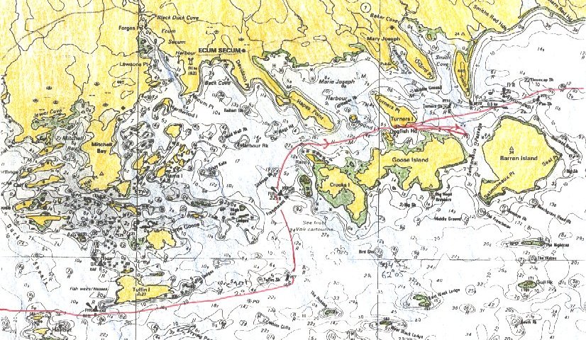
An incessant rain drummed on Naomi’s canvas boom tent. However, a gradual clearing with westerly winds 10-15 knots was forecast for later in the day. After stowing the stiff, wet tent under the foredeck, I sailed from Turners Island. Naomi seemed reluctant to pass the light tower on Thrumcap Rock and leave the shelter of the inner passage. She drifted slowly along while I held the boom out to catch casual whiffs of breeze in her sail. I didn’t see any point rowing as the distances to travel were far. Visibility was okay in spite of an overcast sky and steady rain. Buoys in the distance stood out as black ink strokes on a gray-green palette of lethargic ocean. This drab view was broken by a scattering of brightly coloured pot buoys on the shoals and the busy motion of turquoise, red, and yellow hulled fishing vessels stalking them. Throughout the morning Naomi crawled along the coast as the rain slowed to a drizzle. Once, when I wasn’t paying attention, she nabbed the floating line of a pot buoy and enticed the lime-green and white float under her rudder fittings and brought us to a halt. At the slow speed we made, it was easy to reach down and push the pot under the hull and free of the rudder. In stronger winds snagging a pot buoy is far more thrilling as the buoy jams tightly under the rudder stock, halting her forward motion and causing the dinghy to weathercock downwind. Then I have to haul Naomi’s sails down quickly before removing the rudder and freeing the jammed buoy. The first smear ahead gradually took the shape of bell buoy VT7. A short lime later, Liscomb Island light flashed from its lighthouse on a low cliff. I was tempted to work into Liscomb Harbour and then up the river to Liscomb Lodge for an overnight visit. Why should I be out here drifting about in a drizzle when I could be savouring the heated pool, fine restaurant, and cozy couches of the lodge? I have succumbed on two other voyages. Why not make it three? But I had a difficult time justifying this stopover because I had only been sailing since yesterday. |
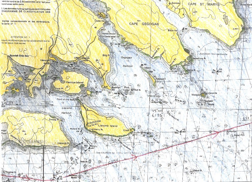 |
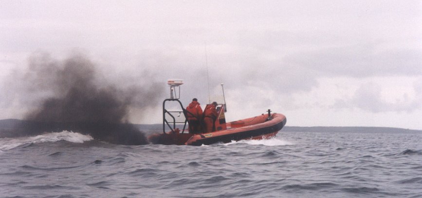
| As Liscomb Island drew abeam, the drizzle stopped and a southwesterly Force 2-3 settled in. Soon a noticeable depression parted the coastal hills, indicating the mouth of St. Marys River. On a chart, this navigable river appears as a good place to shelter from a storm for a dinghy, but the mouth of the river is treacherous with breakers building quickly over the bar. While sailing between Wedge Island and Wedge Shoal, I spotted the bow wave of an approaching small vessel. This Coast Guard boat pulled alongside and the two survival jacket clad crew asked how my passage was going and my destination. I hoped to stop over for the night in Port Bickerton which was their home port. With casual waves and “See you later” from the crewmen, the rigid inflatable accelerated away in a billow of oily smoke from its powerful but malfunctioning outboards. Their departure reminded me of the escape behaviour of squids who eject a cloud of dense black ink and jet away from predators in their smoke screen. |
 |
|
|
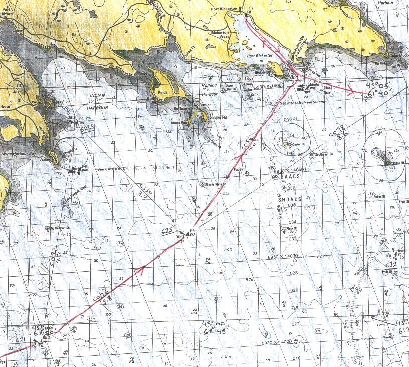 |
| With a freshening wind, white caps became numerous and a sea built as I sailed for Port Bickerton. Near buoy VH2, I hove to, put the first reef in the main, and furled the jib. I rechecked my preset bearing on the chart from this buoy to the port hand buoy off Bickerton Island. The approaches to Port Bickerton are exposed to the Atlantic Ocean. Nixons Mate Shoal extends 2 miles seaward from the shore on the port side. Immediately to starboard of the course, lie Isaacs Shoals which is an extensive breaking shallows and includes Castor Rock and Pollux Rock above the surface. From shore, I have seen seas breaking lustily over this entire approach in moderate weather. Today seas were lumpy over the shoals but breaking only on the drying rocks. Even so, there were many pot floats in the disturbed shallows which would cause Naomi to capsize if we snagged one there. |
 |
|
... |
 |
|
... |
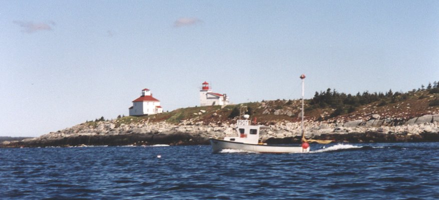
| The entrance to Port Bickerton is distinctive, with two
lighthouses
on a rocky headland. The small green pail buoy off Bickerton Island
Point
is hard to see though. I finally spotted it much further seaward than
where
I had expected to find it. I had a choice of two wharves to tie up at.
The one at the fish plant in Mouton Cove was closer to sail to but it
can
be grimy and smell strongly. I chose the government wharf which is also
the Coast Guard base. The inflatable boat I had seen earlier was tied
behind
a larger Arun class search and rescue vessel.
I visited the base and showered before setting up the boom tent and readying my dinghy for the night. Since a drizzle had begun anew and the convenience store was closed in this small hamlet, I stayed at the coast guard office and talked with the ship's engineer who was on duty. Most of the larger fishing boats were out 30-40 miles catching crabs. Crews were reporting good catches on the radio and they’d return Monday to unload their catch. Quota levels for crab had just been increased, making a welcome source of income after the failure of the ground fish industry. Other than towing a few broken down fishing boats, the season was quiet for the Coast Guards. |
|
|