|
Practical advice for small open boat cruisers by Dick Harrington In September 2000, Wayfarer friends, Abbey Gura from New York, Allan Parry from Manchester, England and I spent two weeks sailing the coast of Maine. The weather was outstanding and the wind plentiful. Allan's account of our cruise along with some of my photos were published in the Fall 2000 issue of the Skimmer. We sailed 'downeast' from Round Pond on Muscongus Bay to Southwest Harbor on Mount Desert Island, down-wind all the way. From there we went a bit further to the head of Somes Sound, Maine's majestic fjord, before returning. As the crow flies this is a total distance of about 160 nautical miles. But considering that there were many stops and side trips along the way, we probably covered almost twice as much ground. If it was blowing, or there was a long passage to be made, Abbey and Allan usually sailed together while I single-handed. September in Maine is a time when
the air
is clear and the winds are at their best. At some point nearly
every
day it was prudent to reef down. Sometimes the size of the jib
also
needed reduction. Abbey and I both have double reefing on the
main
and Abbey has a roller reefing jib. For this cruise I kept both
my
small jib as well as the genoa shackled to the bow fitting at all
times,
with the sail not in use tied on the foredeck. With this
arrangement
by luffing the main and fixing the tiller with a bungy I could easily
switch
jibs in two minutes flat.
 we had the unbelievable good fortune of sailing past the entire fleet of Penobscot Bay windjammers. .. 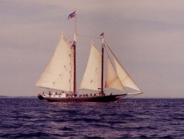 I think there were eight or ten altogether. Sailing as a group they were on their last cruise of the year--the grand finale. It was well past mid-afternoon by the time we located the docks of the local sailing club and landed at the town of North Haven. That morning as we departed Stonehaven, the sun had been shining, but now clouds began to roll in and it was turning chilly. The wind was gusting and a front was forecast to arrive the next day. It would be "breezy". In the vernacular of Maine weather forecasting that usually meant winds just under gale force. Following the front the fine weather we had been enjoying would begin to deteriorate. Once on the other side of Penobscot Bay we still had a two-day sail in front of us. It was now Tuesday so that left only one contingency day. We needed to pull the boats out by Friday as Allan had to be at Boston's Logan Airport on Saturday to catch his flight home. I was nervous. Determined to push on, I told the
others to
go ahead and sail for the west shore. Meanwhile I would make a quick
run
to the nearby general store for a much needed rest room stop, snack,
and
cup of coffee. If I didn't catch up, we were to meet at the High
Island anchorage. High Island was nearly 12 nautical miles
away.
An hour later it was blowing stink. At the mouth of the thorofare
there were lots of whitecaps. I had the main pulled down to the
second
reef and was flying the small jib. About to plunge into a thick
fog
bank on the bay, suddenly I saw a familiar boat emerge from the
fog.
Abbey and Allan
Getting an early start the next morning the wind wasn't as bad as I had expected. Nevertheless while temporarily moored along side the floating dock of a small yacht club, I painstakingly plotted the entire course for the day (we would try for Tenants Harbor), then inputted the waypoints into my GPS. I also entered in a small pocket-size note pad each waypoint, course heading, and the distance of the leg. This, being quite complicated, took some time, which made the other two antsy enough to again leave without me. As it turned out conditions on the bay were not as bad as the day before and there was no fog. Upon catching up with the others on the opposite side and I heard some complaints about holding things up, but I would still do the same again. They would have been wise to have followed my lead. Now the wind picked up and in short
order
we were back into reducing sail. A 10 nautical mile beat down
Mussel
Ridge, a narrow channel with treacherous shoals on both sides, lay
ahead
before reaching Tenants Harbor. The wind was not constant
though,
which meant frequent sail changes--reefing, followed by shaking out the
reef, and once or twice even jib
Critique What lessons can we draw from the above experience? Stick together. I was very wrong to send the others on ahead. In fact I probably had been pushing far too hard throughout the cruise. This was a difficult trip for Abbey. He had not tackled a cruise of this magnitude before and had done little sailing that summer prior to this occasion. As a result I developed a bad habit of ranging too far in front of the others. I needed to prod them along, I thought. When they wanted to go on ahead of me I thought, "OK, that's good". Wrong! It was faulty and selfish thinking on my part. We narrowly missed suffering a serious mix-up. My counterparts in the UK are very adamant about staying close together. The leaders are not allowed to get too far out front and the stragglers are not permitted to fall behind. Reefing. Rarely have I
conducted
a cruise where I haven't had to reef. Yet on several occasions
recently,
I've been with skippers who, though they had taken the trouble to put
reefing
cringles in the main, were ill prepared to take in a reef. These
individuals had not bothered to install the clew, or tack, reefing
lines
needed to perform a jiffy reef. In other
Let's start with philosophy. Don't count on being able to do any course plotting once underway, especially if you're singlehanded. Just going through the gyrations of getting a fix off the GPS and plotting a position is usually a hassle. Do the navigation work before leaving the dock, weighing anchor, or whatever. The GPS is there to be used in an emergency. People who keep playing with the GPS, checking boat speed, etc., drive me up a wall. Usually with these folks the boat's wake looks like a snake and the sails are luffing. Learn to make that wonderful computer God gave you in your noggin do the work. It requires no batteries and has no buttons to manipulate. Use waypoints that are real, not imaginary. If you aren't sure of where you are, and are sailing by GPS, you want to see something, such as a buoy, that confirms that you didn't mistakenly input bad data. My small spiral pocket note book is my best friend. I can pull it out of my pocket and tell instantly the heading I'm supposed to be sailing, what the waypoint is that I'm looking for, and how long it should take to get there. If the waves are five feet high and the chart case is floating in the bilge, I'm still whole. Finally, package your charts so that they are user-friendly and readable at a glance. A glance is sometimes all that you'll get. Tips. Occasionally I
see someone
with a chart stored in a tube. This immediately tells me that the
closest this person has come to navigating is the school desk at the
Power
Squadron or the U.S. Coast Guard Auxiliary navigation course. An
excellent course, but not the final say for sailing a small open
boat.
In a Wayfarer you'll be working from your lap, the boat will be
bouncing,
and water will be all over the chart. On the Great Lakes I've had
good luck with some of those independent compact chart books (called
cruising
guides). I tear out the pages that I'm interested in and cover
them
with clear contact paper. Then I staple them together to make a
small
packet. The paper quality is not as good as NOAA charts but the
contact
paper makes them (semi-)waterproof. Of course I still store them
in a chart case. My Maine charts have a billion creases in
them.
That's because I've folded and refolded these charts many times to get
the maximum exposure of
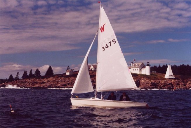
Finally, practice estimating course headings by simply eyeballing the chart and using the side of your hand as a guide. You'll be surprised at how close you can come. Also practice estimating bearings by glancing at navigational objects from over the top of your compass card. I have found my flat-face style compass mounted on center thwart works quite well for this purpose. Sailing singlehanded, there's no way you will ever get to use a hand bearing compass. Photos 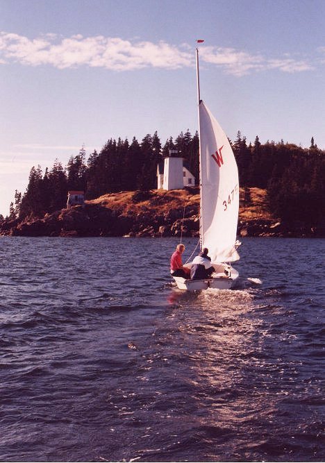 Abbey and Allan off Hockamock Head at Burnt Coat Harbor on Swan's Island. Things look calm here, however, the crossing from Isle Au Haut had been rough but great fun.  A close up of Blue Mist's jiffy reefing. Note the lines at the clew and the 1/8" shockcord reeved through the reefing cringles. Small plastic hooks tied into the shockcord on one side are used to catch a loop pulled under from the opposite side. (The loop in the 2nd reef clew line seen hanging down is not good. I've since added more fairleads to the boom.) ... 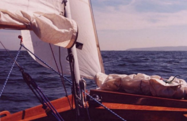 .. ..
..A view looking forward. I use a reefing hook located near the gooseneck to catch the tack reefing cringle. This way no line to the tack cringle is required. Here you see that the small jib is up and the genoa is tied down to the deck handle with quick release shockcord. Also, to facilitate quickly changing the jib, a "ball & loop" are sewn and moused into the jib sheet to catch the jib's clew. 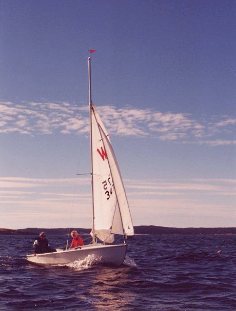 Reefing... ...  ... in action! ... 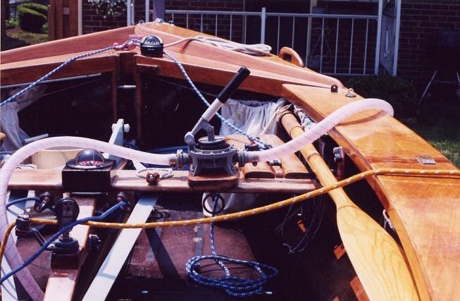 Blue Mist in the driveway. Note the two compasses (the center one is attached by shockcord and easily removed); the bilge pump which can be operated while sailing singlehanded (again attached by shockcord); and oar stowage (this location only works on a wooden Wayfarer). |