| Round
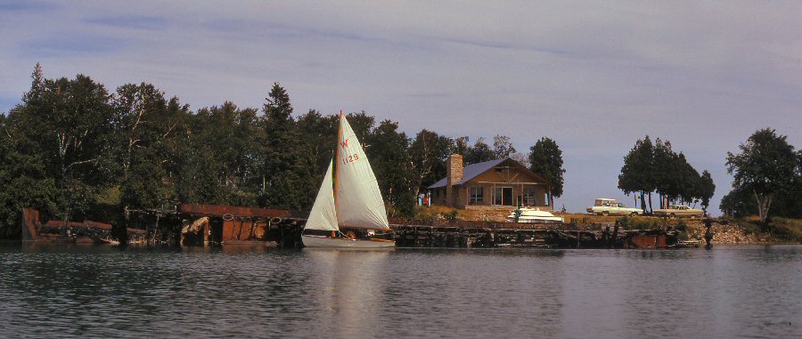
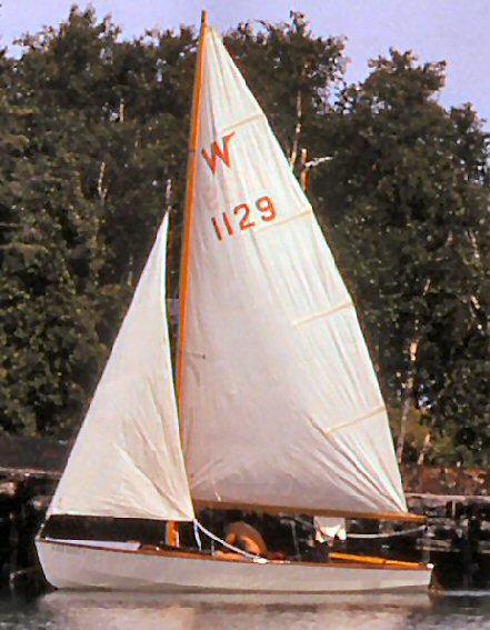
Georgian Bay by Joy Phillips (W866) * July 17-31, 1973 Part 3: July 20-22 ... |
| July 20th Friday. 0610 Woke; boat tossing at anchor. Some fog, wind ENE, Force 2. Dozed till 0715 Got up. Don just up, too. Light breakfast on boat, avoiding need to go back to shore, where waves were breaking. 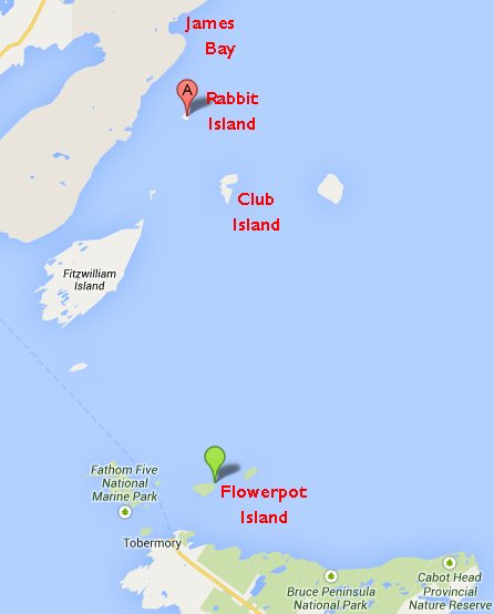 0930
Don's
instructions: Leave Rabbit Island to
starboard; three miles further on leave red buoy
to starboard. 'Ware shoals between our course
and red buoy. 183M all the way to Flowerpot
Island. Set sail - main only.
1005 Set jib. Broad reach. Wind NE or NNE, force 3, waves 1-2ft. 1040 N end of Rabbit Island abeam on starboard side. 1048 S end of Rabbit Island abeam. (Rabbit Island is a little over half a mile long.) 1137 Passed buoy off Club Island. ETA Snake Island 1530. This was a
fairly uneventful day, though it was some of the most
open water we would meet in the whole trip. Any
strong wind out of the west would have brought big
waves from the main part of Lake Huron pouring through
the gap between Manitoulin Island and the Bruce
Peninsula, with only a handful of small islands to
break them up. The north-easterly wind had the
entire width of Georgian Bay to play with - about
fifty miles. Alan was puzzled by the course Don
was taking, and we logged a statement that Don seemed
to be between 5° and 10° off course. We even
investigated the after locker for tools that might be
upsetting our compass. Later that evening, after
hitting Flowerpot Island right on the nose, we learned
that Don took sights on the last view of Club Island,
and altered course to 175M, but had no way of
communicating with the rest of us. There must
have been a 1/2-knot current setting westwards out of
Georgian Bay. A fine piece of navigation, Don!
1316
Passed
a stick, obviously fixed to a rock; puzzled. If
this is Kilroy Patch, we are much further back than we
thought we were. Nothing is marked on the chart
anywhere near where we think we are. Depths
around here are 20-50 fathoms. ETA if this is
Kilroy Patch 0400 tomorrow. At least we shall
see the Light when it gets dark!
1336 Passed another stick, to port. There certainly are not two shoals marked on the chart. Later, we learned that people are still finding rocks and small shoals in Georgian Bay, and these are marked in the water before they get marked on the charts. We were glad we were not the ones to discover any. 1420 Winds now very light and flukey. Hardly making any progress. Sun shining. 1439 Sighted Bear's Rump Island on port bow, and then Flowerpot Island dead ahead. 1630 Landed at Flowerpot Island, Georgian Bay Islands National Park dock. This was a very
fine piece of navigation on Don's part. We had
seen Club Island. In the distance, and
Fitzwilliam Island had been only a bump on the
horizon, but we came squarely on to Flowerpot Island
fifteen miles to the south.
This part of
Georgian Bay Islands National Park is
delightful. It is very small as National Parks
go, and there is a move to keep it that way.
There are only six spaces for tents, and there is room
for, perhaps, half a dozen boats at the dock and a few
more moored in the cove. Access is by boat only
- either your own or one of the privately run ferries,
which arrange their schedules to suit the passengers'
convenience. We are with those who want to keep
it small - a vast tenting area would ruin the whole
thing.
One of the
ferries from Tobermory (Penguin: captain, Joe
George) tied up soon after we did. Our first
question was: "Is the Tobermory Post Office open on
Saturday?" We were getting very close to our
gooseneck at last. Joe even offered to inquire
at the Post Office and bring any mail over for us, in
the morning, but we wanted to do this ourselves.
During the
evening we had a very definite advantage from being in
a National Park rather than in a completely
uncontrolled wild spot. A biggish cruiser was
moored in the cove some 300 yard from us, and
glamorous girls were sprouting all over.
Presently, a loud-speaker began blaring raucous music,
and a voice on the loud-hailer shattered the peace of
the bay, shouting "Where is the Champagne? Hurry
up with the champagne. If you don't get over
here with the champagne, I'm going to start on the
Drambuie". Some of the campers began shouting
back: "Shut up. We come here for peace and
quiet." After a while, the boat did shut up and
the silence was suddenly complete. Next morning
we learned why. The Warden, hearing the racket,
realized that the boat was on Citizens' Band radio, so
he called them up with his own and told them to be
quiet. The people on the boat were mystified,
and asked the radio where this voice was coming
from. "I'm in the cottage you see 200 yards up
the shore." "What is that?" "The Warden's
cottage." Instantaneous silence! The
Warden told us next day, that he had had noisy people
on boats who absolutely refused to be quiet or to move
on when asked to do so, and he had taken an axe to
their mooring line. More power to him and his
axe-arm!
This evening we
had plenty of time to cook super, clean up and
relax. The stars were out in force, and we had
an interesting time identifying all we knew, among so
many more than we ever see in the city.
July 21st Saturday. Up around 0700,
cooked breakfast and washed dishes before the others
were up. Walked to lighthouse on north shore of
the island. There is a beautiful trail through
the woods and along the shore. The Flowerpots
that give the island its name are strange
configurations of limestone topped with dolomite. They
may have begun as columns separated from the
main cliff by the twisting action of a glacier, and
the softer, lower strata have been partly worn away by
the action of weather and waves, leaving rather
top-heavy "Flowerpots" which are now quite a tourist
attraction. They are even protected against
further weathering, to some extent, by artificial
replacement of the limestone round the base (and the
original formation is very cleverly imitated) and by
"caps" of asphalt.
All along the
trail through the woods, are signs to various caves -
six in all - and to the Sentier Mountain Trail.
We did not take this, but Tom reported that it leads
to a green meadow in the middle of the island,
surrounded by high cliffs. We learned later, in
conversation with the Warden, that this is where the
lighthouse-keepers' wives used to grow their gardens;
furthermore, before the coming of electricity (the
'Hydro' as everyone calls it) Cave No. 4 was the
lighthouse-keepers' refrigerator! We had talked
to the keeper the previous evening, and he had offered
to show us the lighthouse, but when we went up to it,
he was not there, and we didn't like to go to his
house, as there was a notice asking visitors to be
quiet because the man off watch would be
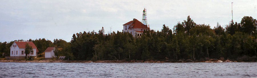
sleeping. The lighthouse is one of the modern
type of construction - a skeleton steel tower face
with panels of white fiberglass for easier visibility
by day; in the calm weather and bright sunshine,
the blue water of the bay looked so peaceful, that it
took a little imagination to picture the keeper
climbing up inside the iron hoops provided round the
ladder for his safety, and really needing the
protection. The lighthouse itself is a little
way from the keepers' houses, along a concrete path
and up some steps. It stands on a platform about
halfway up the cliff, and commands a fine view over
the Bay, Bear's Rump Island lying peacefully about two
miles away. The lighthouse itself is 91 feet,
and the flashing light is visible 15 miles. It
is powered by electricity and the keeper had told us
the previous night that if the electricity fails,
there is only an 18 second delay while the reserve
diesel generator kicks in. Before the advent of
"Hydro", kerosene was the fuel. The keeper
seemed to regret that he is no longer called upon for
the craftsmanship of being a lighthouse keeper, able
to repair his gear; he is a technician now, for the
electric equipment, and had to call the mainland for
major repairs.
Not far away
from the lighthouse is a 225-foot radio tower.
We were speculating about the problems of replacing
bulbs in the red lights atop it, and even more about
what happened if a guy wire broke! On the way
back from the lighthouse we met the keeper, and he
said that in this case he does not start
climbing; he calls Toronto! His two-way
radio connects with the telephone system at Wiarton.
Walking back
from the lighthouse, we explored one of the caves and
found a real stalactite. It did not connect with
a stalagmite as it had formed above a shelf, and
united itself to the edge of the shelf. We
explored the Flowerpots, too, climbing right down on
the shore to get a close view. It is a pity that
the Government has had to give them artificial
support, but apparently there used to be three, and
one has toppled over some time during the three
hundred years since the first European explorers
paddled this way.
On this walk we
saw the only snakes we met in the whole cruise - two
garter snakes. The Flowerpot Island brochure
assures visitors that there are no poisonous snakes on
the Island.
Back at the boat, we brewed up a well-earned cup of tea! After a
leisurely lunch, we caught the Penguin at
1300, and became tourists for a while, watching the
other side of the island go by and listening to the
skipper pointing out things of interest. Joe
George is a former high school teacher, whose tales of
touring with his school band pleasantly filled the
time between the Flowerpots and the points of interest
around Tobermory. (Tubbermurry as we learned to call
it, if we want to sound as if we know!)
Tobermory has
two harbors - Little Tub and Big Tub; Big Tub
seems to be the haven for big, rich yachts and Little
Tub for lesser mortals and commercial traffic.
Joe put us off at Little Tub, recommended a restaurant
for supper, told us where to get hold of him when we
were ready to return, and - perhaps most important of
all - directed us to the POST OFFICE!
Full of
expectant trepidation, we trooped up to the Post
Office and asked if there were a package for
Phillips. The lady said "Dr. Phillips?" and
riffled through the stack of mail for the Ps, while we
hovered on the other side of the counter. She
produced a yellow package, and with bated breath we
watched Alan tear it open - even tearing one of the
beautiful stamps, until warned to be careful with them
- and there, in the palm of his hand, lay a beautiful
bronze gooseneck! With it was a letter from Dr.
Riddell of Kitchener, Ontario, which read:
Good Morning!
Our misfortune is your fortune. Broke our wooden mast on the weekend. I phoned Eric Stubbs to inquire about getting a new one and he told me of your plight. Replaced ours with a metal mast and do not need this gooseneck. I hope it reaches you without too much delay, so that you may continue your trip. Press on! W.R. Riddell, D.C. Thank you, thank you, thank you, Dr. Riddell! And what wonderful people in C.W.A. - that he ever heard about our problem. With minds at
rest, we proceeded to the rest of our shopping - which
included shackle pins, so that we could replace
the toggle pins on the shrouds, and avoid the
near-disaster that happened when one worked loose on
Monday afternoon. (Ever since then, by the way,
the drill had been "Ready about! (Check the
toggle pin) Hard a-lee!") It seems that no
one in Tobermory carries sailboat supplies. We
walked about five miles in search of boat hardware
without success - though a kind motorist picked up
Don, Tom, Connie and me when we decided to turn back,
and Alan and Pete had a ride back to Little Tub from
Big Tub by water, when a kind Chicago millionaire ran
them round in his dinghy.
After supper,
Alan decided to have a haircut, and found a barber who
was a real gem. This fine gentleman was over
eighty years old, and had a fascinating 70-year old
barber chair that he had rescued from destruction 25
years ago, and refinished for his shop. It was
beautifully carved. Despite a severe handicap
with arthritis, he cheerfully carried on his business,
looked after a beautiful garden, and "tried to keep
his house the way it was when his wife was alive".
Back at the Penguin,
the rest of us were watching other boats in Little Tub
and listening to Joe getting orders for ice on his
radio. I am commanded by the others to include
in the log that we watched a little dog, on the
foredeck of a big and beautiful sailing boat, quietly
pee down one of the ventilators. When Alan
appeared, Joe went and picked up his four blocks and
two bags of ice, and we were off to Flowerpot Island
again.
It was getting
dusk by the time we were back, and everyone was eager
to see how our gooseneck fitted. It was a little
too big for our track, but Engineer Hanson supervised
the filing of it, and before putting up the tent that
night, we fitted it. What a joy! (Engineer
Hanson also came up with a method of preventing the
toggle pin from undoing itself, by stuffing it with a
piece of paper-clip.)
July 22nd, Sunday. 0910 Set sail for the Bruce peninsula. Course for Cabot Head - 014T, 112M. Our heading - 107T, 115M. 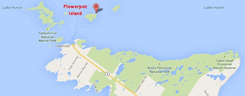 If close-hauled,
we could just have fetched Cabot Head, but Don wanted
us to see the North coast of the Bruce, because the
cliffs are spectacular. We therefore fell off to
a close reach, and agreed to rendezvous at Cabot Head,
in Wingfield basin. Cabot Head easily visible,
over fourteen miles away. In clearing the
anchorage on Flowerpot Island, we had hit a rock, so
once we were sailing, I checked the forward locker for
water, and found it dry.
While I was
guddling in the forward locker, the spring that holds
the watch-strap on the watch came off, and so
the log records that there is no detailed log for the
next few hours We sailed a close reach till we
were near the Bruce Peninsula and then tacked along
the coast. The wind freshened to a good Force 4,
waves 3-4ft; and then fell light soon after noon
- Force 2, waves 2-3ft. The cliffs along the
shore really are spectacular - 100-150 feet high in
places, with trees down to the shoreline in parts, and
other parts bare rock or scree.
At the foot of West bluff, about two miles from the lighthouse on the point of Cabot Head, we saw a back-packer who was evidently walking the Bruce Trail; we waved to each other. There seemed to be several beaches, but none of them turned out to be sandy; all were shingle and rocks. The sun was hot. 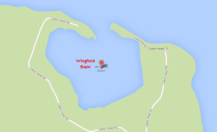 1430
After
a rendezvous in Wingfield Basin, we departed without
landing. (Later we learned that Wingfield Basin
is thick with poison ivy; our reason for not
landing was that all the land closest to the mount
seemed to be private and we did not want to take the
time to cross the basin to what appeared to be a
public spot. By now, the wind was almost gone.)
1510 Course to clear Smoky Head 175T, 183M. 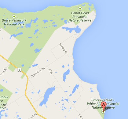 We had now only a slight breath of air, and hot sunshine. The three boats were separated by a quarter of a mile or so from each other, and I could imagine the others lying back, Dow in hand, radio on (and not to Mafor either,) taking it easy. Not so W866. The log reads: 1528 Set spinnaker, down main (much more comfortable without main under these conditions of light wind and moderate waves.) Wing out jib on opposite side. 1531 Gybe spinnaker 1536 Gybe spinnaker back again. 1540 Lead spinnaker sheet inside forestay (considered safe in this very light air.) 1600 Lead spinnaker sheet through working-jib fairlead on port side. Lay out washing
to dry - eat chocolate - move washing around - drink
water - all the time, fiddling with the spinnaker and
jib sheets.
1610
Wind
(what there was of it) on port quarter.
Spinnaker boomed out on starboard side. We were
about one mile offshore and gradually overhauling Tom,
two miles offshore. Don, also fairly far
offshore and quite far behind - further away from both
of us than we were from each other. Alan chose
our course to catch the sea-breeze he hope would
spring up.
1630 Wind veered to port beam. Down spinnaker. 1700 Rowed for half an hour. 1730 Wind picked up to Force 1. Cheers! Wing and wing, gybing every few minutes. 1855
Abeam
Cape Chin (7 ½ miles from Cabot Head in 4 ½
hours.) Very light wind, NW Speed now
1kt. ETA Smoky Head 2200.
2020
Smoky
Head abeam. 3 miles in 1 hr. 25 min, so speed
since Cape Chin 2kts. Course south, wind WNW,
Force 1. ETA White Bluff 2200.
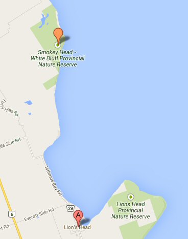 2145
Abeam
White Bluff. Wind N, Force 1. ETA Lion's
Head Harbor 2245. Dead run, starboard
tack. 2 ½ miles to go, estimated speed 2 1/2kts.
Tom and Pete
appear to have taken shelter for the night behind
White Bluff. Don and Connie have not appeared
round Smoky Head, and have probably taken shelter
there.
...Rowed from the middle of Isthmus Bay into Lion's Head Harbor. 2305 Tied up at the Government Wharf, Lion's Head. Sandwich and bed. A good, clean washroom here - contrast with Killarney Government Dock, where there was none. Observe that the choice of course in mid-afternoon, and all the fiddling with sails, have paid off in that we are the only boat to reach Lion's Head tonight. One slight problem getting in - chart shows a fixed green light marking harbor entrance. There were two fixed green lights, and for a time it was not quite certain which was the harbor light. The other appeared to be some kind of private light - perhaps for advertising rather than navigation, but they looked exactly alike from seaward. |
| next page return to Cruise Logs index |