| Round
Georgian Bay by Joy Phillips (W866) * July 17-31, 1973 Part 6: July 29-31 ... |
| July 29th Sunday
A wild
night! The waves were washing over the dock and
rocking us badly. 1129 bumped 866 during the
night, and Tom and Pete got up and moved her to the
end of the dock.
0730 Breakfast on the dock. Don's anemometer says 8-9k, but everyone agrees it looks more like 12. Someone comes and tells us that 1129 is tied up in the spot the ferry uses, and the ferry-boat is half-way across the bay on its way in. We wake Tom and Pete in a hurry, and their boat is out of the ferry's docking-space by the time the ferry gets in. A Tanzer comes in, single handed by a man who looks familiar, but I can't think where I've seen him. After washing dishes, I went to join the others, and immediately he said, "I've seen you before somewhere." Neither of us could remember where, for sure. Very unsatisfactory. Agreed on main only. 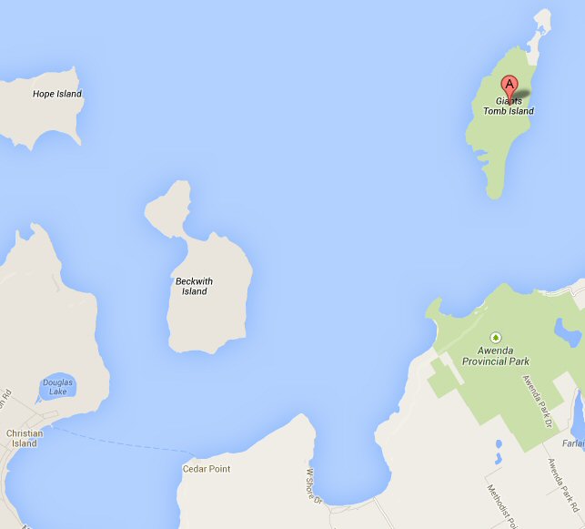 1005 Away from dock. Close/beam reach on port tack, wind Force 3. Heading 035, going to lee of Giant's Tomb. Speed 4kts. 1055 Working jib up. 1114 Buoy off Giant's Tomb abeam on port side. Heading 075M, 067T. 1124 Giant's Tomb Lighthouse abeam. 1138
Changed
from working jib to genoa. Wind slightly calmer
- some shelter from islands. Everyone else has
had genoas on, since our working jib went up.
1148 Passed Vic Searles on Aku Aku again. Much waving. 1153 Light (FL. R.) off Sawlog Point abeam on starboard side. 2 ½ miles in 29 mins. Speed 5kts. 1211 Quick flashing red light between Adams Point and Smooth Island abeam, starboard side. 1 ½ miles in 18 minutes - speed down to 4kts. 1215 Turned up to beam reach. Skipper remarks "Lickety splittus" 1235 Into channel. This is about two miles further on than the quick-flashing red in 24 minutes. Speed 5k again. Lickety split is right! 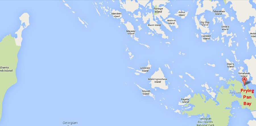 1313
Into
Frying Pan Bay. Although the log has no entries for
the last forty minutes or so, we were extremely busy.
This is where we joined the Small Craft Channel again.
It is well-buoyed, and it needs to be. There are
dozens of islands and at this point, except for
Beausoleil Island itself, they are mostly very
small; some are just named rocks. The names
indicate the history of this area. Some are
Indian - Minnicognashene Island, Penetang Rock; some
are French - Beausoleil and Breboeuf Islands; some
English - Blueberry Point and Cherry Point sound
distinctly attractive. Some suggest an intriguing
history - Gin Islands are all very well, but what
disaster happened on Gin Rocks? As we went
through this part of the channel it was a glorious,
sunny afternoon. The water was blue, the islands
green and gray and there are other people sailing. In
particular, we noticed a Fireball with a spinnaker,
and the crew out on a trapeze, just flying along.
After tying up, we spent the afternoon swimming, housecleaning and cooking supper. Once more, with ample time, we did ourselves proud - corned beef fritters, mixed veg., stewed apples with evaporated milk, and coffee. There were some boats with whose crews we had instant affinity - our immediate neighbor was from Detroit, and a little further along was Eric Blythe, in his Wayfarer. At last, news of Hugh - he came to Beausoleil, but his crew had other commitments, so Hugh went back. It is a relief to know what happened; thoughts of Hugh have been nagging us every time we got one port nearer Beausoleil, and every time we saw a lone boat on the horizon. Pity he couldn't join us. After supper,
Don, Pete and Jim went to talk to Eric Blythe, his
charming wife and delightful boys, Jonathan and
Christopher. They had been based on Fryingpan Bay for
nine days. Tom went to talk to our Detroit
neighbors, and Connie and I stayed around camp,
cleaning up supper, swimming and getting the boats
ready for night.
A problem is beginning to loom; our drinking water supply is very low. The last time we could drink the lake was just off Vail Point, and I filled up the drinking water jug on Thursday morning in one of the slack spells when there wasn't much sailing to do. (In fact, I think Don took a movie sequence of me apparently bailing the lake into the boat; actually I was filling the water jug, one cup at a time, after it reached a level too heavy to dunk overboard and fill that way.) There was no drinking water at Meaford docks, and the Reef Boat Club at Thornbury bring plastic bottles of drinking water in, so I didn't feel we could ask them. Here at Beausoleil is a Government Camp Site, where we were counting on finding drinking water in a pump; but the pump has a sign around its neck to say that its water is for washing and cooking only. We have less than a quart left, which will do for breakfast, but what then? 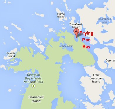 2130
866
almost asleep. Tonight, we are in such a protected
spot that none of us put out a stern anchor. We are
pulled up a little, on the beach, and tied to a tree.
This looked better for sleeping head-to-bows and we
tried it that way. Having heads higher than feet had
looked sensible, but we found our hips completely
fastened down by the center thwart, and we couldn't
move - except to wriggle out, which we did after an
hour or so, and turn head-to-stern. This was not
much better.
July 30th Monday 0330 Clatter, clatter, clatter! Rousing ourselves from sleep, we heard the dixies and the garbage scattering around. This could mean only one thing - my old friends (?) raccoons. I once lost a slab of fruitcake the size of a roasting pan to raccoons, and have been insensible to their charms ever since. This time, I had taken care to leave nothing attractive except garbage available to them. Everything was either in the boat with us, or fastened in the cooler. We heard Pete get up and shine a flashlight on them, and sure enough, there were five raccoons, one staring right into the tent. Whether it was Pete's flashlight or Pete's comments, I don't know, but they scattered and didn't come back. There was a short discussion (from under the respective tents) about the cooler. I felt it was more or less raccoon-proof; Tom felt that the rascals are quite clever enough to get in. Anyway, they didn't and in the morning all we had to do was collect our garbage from an area of approximately half an acre. 0645
Woke
and got up. It was very pleasant to be the only
person around in the early morning sun. I swam,
washed a pair of shorts, aired my sleeping bag and
cooked breakfast - all because sleeping was so
uncomfortable with the boat pulled up on the shore!
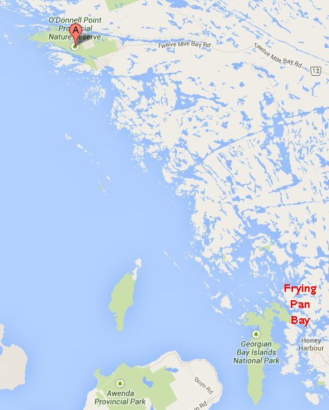 1000 Off again. We are planning to go to O'Donnell Point today. 1007
Passed
Ardiluan Light. This brings us into a rather
more open part of the channel than Frying Pan Bay, but
still not out on to the open Bay.
1016 Passed red mark 72. A little over half a mile. 1022 Passed red daymark. Speed 3 ½kts. (almost 9/10 mile in 15 minutes). 1036 Passed red daymark on Penetang Rock. Speed 3kts. 1046 Passed light on Kindersley Island. ¾ mile in 10 minutes - speed 4 ½kts. 1053 Passed red daymark on south end of Long Point Island. 1055 Passed red buoy 76 in line with north end of Long Point Island. 1103 Passed black buoy 85 west of Birchall Island. 1115
Passed Newton Island Light. This is two miles
from Kindersley Island, and is at the beginning of a
long (almost seven miles) stretch of open water.
1117 Overcast. Rain coming. Fairly strong beam reach. 1137
Red
Rock abeam. Two miles from Newton Island.
Speed about 5kts. Jim thinks we have been
planing a little - with all this gear on board!
1142 Passed the red marker on Felix Rock - nearly half a mile from Red Rock in 5 mins. Everything is shades of gray - blue-gray sky, steel-gray water. 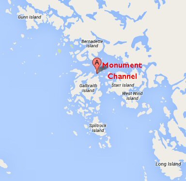 1146 Hove to on port tack by black buoy; here we have to decide whether to go outside for the rest of the way to the spot where the channel goes inside, or to take an alternative passage inside, through Monument Channel. It is pretty wild by now, but Tom has taken the outside passage. That will certainly be quicker, but the weather is getting wilder and we still have full sail up. Everyone is beginning to be a little restless; I think that if we had planned to sail for a month, everyone would be perfectly content, but the planned cruise is now nearing its end and we are restless to get back to Parry Sound. Anyway, we shall consult Don about going inside Monument Channel or outside all the way. After a brief
discussion, we decided to stick together and go
outside. As soon as 866's jib was drawing again,
she took off like a seagull, with the skipper (I
should remind you that Jim was now skipper, not Alan)
exulting "And off we go! Get a load of
that! Man, this is really sailing!"
From 1154 to
1215, the log records the passing of various red and
black marks, and at 1215 we passed the black buoy 107,
where the other end of Monument Channel comes out to
join the outside passage nearly 2 ½ miles from the
black buoy where we hove to, and where Monument
Channel goes inside. We certainly couldn't have
gone inside in 21 minutes! Speed over this last
bit was 7 knots.
1222 Spray Rock and red buoy 92 abeam - this is nearly 7/10 mile in seven minutes. Really tearing along. 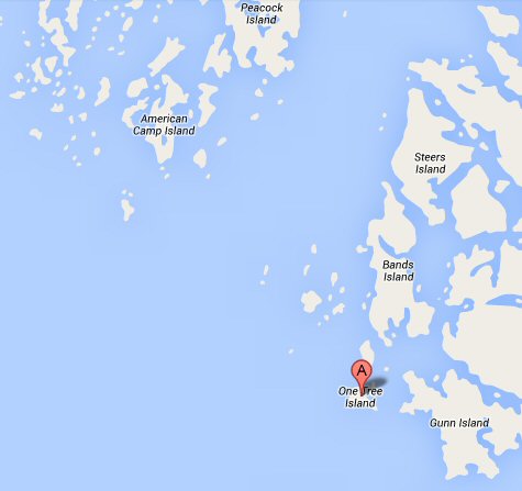 1225 One Tree Island abeam - and it is one tree, too! 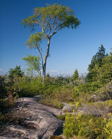 In the next ten
minutes, the log notes a daymark and two buoys, only
one of which is on the chart. This happened many
times along this part of the Small Craft Channel, as
our chart is two years old.
1242 Between red 98 and black 109. This is the pair that is staggered on the chart; it is the first pair by Peacock Island, and is nearly 1-2 miles from One Tree Island, so we are slowing down a little. 1246 As we came between 113 and 100, the pair by the NE corner of Peacock Island, two powerboats passed us. One slowed down very courteously and the other didn't slow at all. What a difference! Ever since One-Tree Island we have been coming very slightly east of north. Now we cut a little inside the marked channel, which seems to take an unnecessarily wide curve, and turn just a shade north of west. 1323 Bourke Point abeam. (Gooseberry Island opposite.) About 2 ¼ miles in 31 mins. 1330 Rounded 106. Course and heading now NW. 1344 Passed The Pig and black buoy 125. (Why is it called The Pig?) 1400
Arrived
in a beautiful little basin at O'Donnell Point,
extremely well protected, after ghosting through a
channel with rocks just below the surface, reminiscent
of Vail Point. Tom and Pete had gone to the
picnic ground nearby, which did not entail going
through the narrow channel over the rocks, but it is
much less well protected and camping is not allowed
there. We hoped they would join us soon - they
could not have failed to see us. Our spot is
completely wild - not an official camping or picnic
place at all. It is just a basin, protected on
all sides, with rocks and trees.
A few minutes after we had landed, Tom and Pete did join us. There was some discussion about going further, even though we had reached the spot we intended to. It was so early, and the wind was favorable, but it had been quite a wild ride, and most of us wanted to stay, camp, swim and explore. We did all these, and cooked on an open fire, which Connie got going in no time flat. There were some logs and pieces of tree across the basin which had obviously been cut down, and Pete was curious to know whether it was human or beaver work. Connie and I swam across and fetched some samples, which were beaver-chewed. The men tried fishing once more, with the same luck as before - zero. They did get their lures snagged in water-lily stems more than once, so the 'Swimming Messenger Maids' had to go and release them. In the course of exploring, Tom and Jim decided that the water off the point looked drinkable (the water in the little basin was too earthy and weedy and still) so they went and filled our water-jug. First drinking water for four and a half days. Rain began to fall just before dusk, so we turned in. July 31th Tuesday 0840 Departed O'Donnell Point. Broad reach. The next 41 minutes in the log record a succession of marks passed, but there is little point in writing them up in detail as the numbers are not on the charts. 0921 Passed black mark at east side of Starvation Bay, about 1 ½ miles from O'Donnell Pt. Speed about 2kts. Tom could have said "I told you so", as he had suggested going further yesterday. He didn't. 0931 - 0946 Sever marks passed, all recorded in detail in log. 0950 Passing McCurry Rocks and starting 1-3 miles of a fairly open water. ETA Copperhead 1015. 1015 Jewell Point. The orange daymark on Copperhead, according to the chart, is no longer there. There appears to have been a fire, and a big Spanish-type house there has been wrecked. There is a roof on the ground beside the ruins of the building, but otherwise it looks very much like fire-damage. Explosion, perhaps? 1022 Passed 163, black buoy by Frying Pan Harbor: quite a different place from Frying Pan Bay where we spent the night before last. 1030 Into Sans Souci Marina. Coffee all round - no film available here; we should have had to go to the store round the point. Didn't feel like stopping again. 1048 Out of Sans Souci. 1113 Wind is "paltry zephyrs", according to Jim. A biggish powerboat passed us at moderate speed. Joy, on the tiller, remembered to take wash on quarter both ways, but we got a fair tossing as we had little momentum of our own. When powerboats slow down we wave cheerily, but ignore the hogs with the contempt they deserve. Rigged light-weather jib sheets. 1152 Wind - more paltry zephyrs, Force 2. Passing NE of the Gauge Islands. A little further, on the starboard side, is Chamberlain Island, and a Wind Charger is marked on this island. When we were well past it, we should have been able to see it, but we weren't. 1204 Passing equal interval light on Turning Island. (Not the same Turning Island we passed the first day.) 1205 Wind picking up. Restored heavy-weather jib sheets and put on foul weather gear. The weather is brewing up. 1216 Passed first of three daymarks between Campbell Island and Bear Head. 1218 Rain. Our (old) chart is not too accurate here in the marks it shows. Some thunder. Rigged light anchor-chain as lightning conductor. 1247 Passing double red daymark by Sleeth Island. The channel here is narrow, and would be very pretty in good weather. Today, it is gray and rather closed in and humid. 1256 Passing red daymark by Moonlight Island, 0-2 miles from Sleeth Island. 1301 Passing black buoy 113 by Copegog Island, another 0-2 miles. 1304 Don says Mafor reports no thunderstorms here - only in Southern Lake Huron. What we are hearing must be artillery practice! 1343 Passed inside Iron Rock; Iron Rock is about two miles from the mark by Copegog we passed 42 minutes ago and is the start of another more open stretch of water. At this point, each boat took a different route from the others. We went inside Iron Rock. The Channel goes outside, and for the next 2 ½ miles there is plenty of deep water, so each boat went wherever the skipper thought there might be better wind. 1400 Approaching Oak Island which has a range (about ¾ mile past Iron Rock.) Running, whisker pole out; still raining with thunderstorms. 6 ½ miles to go. 1530 Sailing by ash breeze! Jim remarks that we are about 10 minutes' rowing away from Pengallie Bay, and we could beat there in half an hour, so we stow the oars and sail just to preserve dignity. 1600 Landed at the Pengallie Bay dock. Brewed up tea. Now we are home again, with drinking water at the turn of a tap and no centerboard in the middle of the bed. But if we had a chance to do it again tomorrow, we'd be off like a seagull. 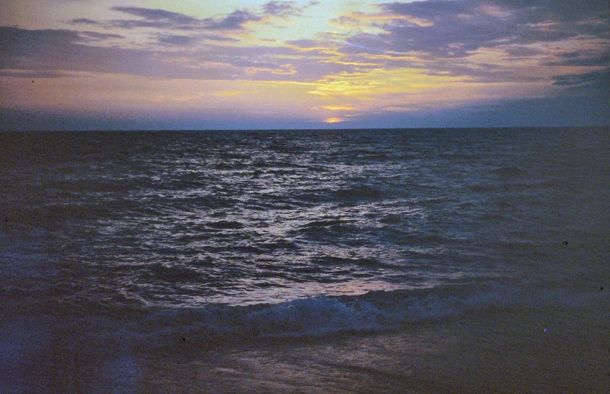 |
| return to Cruise
Logs index |